Location
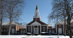
Our church is located at 300 Glenn Avenue in Glenshaw (Shaler Township), Pennsylvania, about seven miles northeast of Pittsburgh.
To get a street map showing our exact location, here are links to three popular map websites:
We also provide driving directions below from downtown Pittsburgh and from the main interstate highways that serve the area (the PA Turnpike and I-79).
Directions from Pittsburgh
- If you are coming from the downtown area (near Point State Park), follow the signs to 279 North, crossing the Fort Duquesne Bridge. If you are in the uptown area (near the CONSOL Energy Center), follow the signs to 579 North, crossing the Veterans Bridge. 579 North becomes 279 North about 1/2 mile after you cross the Allegheny River.
- Take the McKnight Road exit (#11) and get in the right lane (Evergreen Road sign).
- Turn right onto Evergreen Road.
- Follow Evergreen Road as it goes up and down a hill. At the bottom of the hill, proceed straight at the light, as Evergreen Road turns into Babcock Boulevard.
- At the next light, where Monte Cello's restaurant sits on the right, turn right onto Thompson Run Road.
- Proceed north on Thompson Run Road for about 1 mile, then turn right onto Vilsack Road.
- At the next light, turn right onto Mount Royal Boulevard.
- Proceed about 1 mile south, past the Shaler Plaza shopping center on the left, then the Bock Funeral Home on the left. Just past the funeral home, turn left onto Glenn Avenue.
- The church is less than a tenth of a mile down Glenn Avenue on the right. There are two parking lots behind the main building - one to each side of the preschool / CE building.
Directions from the PA Turnpike
- Take the Butler Valley / Route 8 exit (#39), then follow the signs to Route 8 South.
- Proceed about four miles south on Route 8, past the Walgreens drug store, and at the second light beyond Walgreens turn right, go immediately over the railroad tracks, then take the next immediate left onto Glenn Avenue.
- Proceed up the hill and, just past a left bend in the road near the top of the hill, our church sits on the left side of Glenn Avenue.
Directions from I-79
-
From points south of Pittsburgh:
- Take the Pittsburgh exit (#59A) onto Route 22/30 East.
- Follow Route 22/30 east toward downtown Pittsburgh, proceed through the Fort Pitt Tunnel, and follow the signs to I-279 North.
- Follow the "Directions from Pittsburgh" above, starting with the second bullet point.
-
From points north of Pittsburgh:
- Take the Wexford exit (#73) and turn left onto Route 910 East.
- Follow Route 910 east for about eight miles until you see signs for Route 8.
- Turn right onto Route 8.
- Proceed about six miles south on Route 8, past the Walgreens drug store, and at the second light beyond Walgreens, turn right, go immediately over the railroad tracks, then take the next immediate left onto Glenn Avenue.
- Proceed up the hill and, just past a left bend in the road near the top of the hill, our church sits on the left side of Glenn Avenue.

